Wednesday, 7 April 2010
Tuesday, 19 May 2009
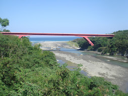
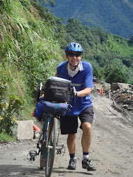
The South Cross-Island 500 Loop
The following article is a testimonial of our trip on the south cross-island highway in southern Taiwan
South Cross-Island 500 Loop
Pre Trip: Blue Skies set me up with all the gear I needed in order to tour on my rented mountain bike (rack, bike bags,camping equipment, rudimentary repair kit and spare parts, etc.) and provided me with a thorough list of all the other equipment I'd need ...snacks, proper clothing and so on. Although the bike was fully loaded, it was quality lightweight gear, so I probably had less than 20 pounds on the bike.
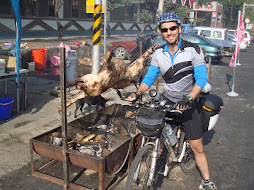
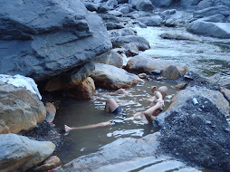
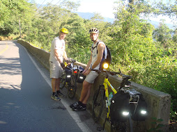
Day 1 Kaohsiung to TaoYuan: We set out from the outskirts of Kaohsiung at about 8:00 a.m. And although the scenery on this early section of the ride didn't quite compare with what was to come later, the route seemed well selected to avoid the worst of the traffic and for relatively easy riding (i.e. no big hills). Some moderate climbing began later just before we reached the town of JiaXian where we enjoyed lunch and some of the delicious local specialities, taro cakes etc. From JiaXian we were on the South Cross-Island proper where the scenery and relief seemed to rise on cue. We arrived in TaoYuan, after passing through the famous hot spring town of BaoLai, in plenty of time to set up camp. Enjoyed a well-deserved soak in the on-site hot spring before turning in.
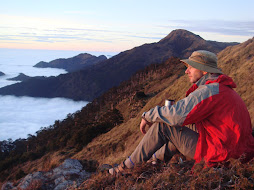
Day 2 TaoYuan to LiDao: We got a fairly early start after a hot breakfast. We'd need it today since, although this was the shortest day in terms of distance, it involved by far the most climbing. When we reached the highest point on the ride, YaKou at 2,722m elevation, Mark very wisely advised me to “put on every bit of clothing” I had with me. And good advice it was for after emerging from the long YaKou tunnel on the east side of the central range, the weather was clear but the wind bitingly cold. However, a little discomfort is again well worth it for the fantastic scenery. From Yakou we rolled downhill, soon into the clouds (again glad to have put on warm clothes) and arrived in the pretty aboriginal town of Li Dao after a stop at Li Song hot springs.
Day 3 LiDao to SiChongXi: The weather was cool but clear in the morning so we got a better look at the very beautiful setting of this town than we had got through the mist of the night before. Although this would be the longest ride of the trip, it was fortunately mostly downhill for about the first 40km, passing through the magnificent Wulu Gorge to Taidong on the coast and then mostly flat the rest of the way. The weather was fine and warm once we reached the coast and it felt like we'd jumped quickly from winter to summer. A relatively short climb (about 480m) from DaWu to ShouKa before rolling downhill for the last 30km or so into SiChongXi and the famous hot springs.
Day 4 SiChongXi to Kaohsiung: Fine weather again today, but it would be hot before we arrived back in Kaohsiung. The route was relatively easy and flat, through CheCheng and along the Coast road (stopped for a refreshing sea dip) as far as Fangliao before turning inland. Frequent rest and snack stops in the many aboriginal villages we passed through were appreciated, after yesterday's long ride.
On the whole, the trip was very well-planned and arranged: There were no surprises other than the pleasant kind and we were prepared for all the conditions we encountered. I was especially impressed by the fact that we had the opportunity for a hot spring soak at the end of each day. The only constructive criticism I would offer is that, if possible, this trip is better done over 5 days rather than 4 as day three was rather long. . Level of difficulty 4.
Paul Campagnaro
Guelph, Canada.
South Cross-Island 500 Loop
Pre Trip: Blue Skies set me up with all the gear I needed in order to tour on my rented mountain bike (rack, bike bags,camping equipment, rudimentary repair kit and spare parts, etc.) and provided me with a thorough list of all the other equipment I'd need ...snacks, proper clothing and so on. Although the bike was fully loaded, it was quality lightweight gear, so I probably had less than 20 pounds on the bike.
Day 1 Kaohsiung to TaoYuan: We set out from the outskirts of Kaohsiung at about 8:00 a.m. And although the scenery on this early section of the ride didn't quite compare with what was to come later, the route seemed well selected to avoid the worst of the traffic and for relatively easy riding (i.e. no big hills). Some moderate climbing began later just before we reached the town of JiaXian where we enjoyed lunch and some of the delicious local specialities, taro cakes etc. From JiaXian we were on the South Cross-Island proper where the scenery and relief seemed to rise on cue. We arrived in TaoYuan, after passing through the famous hot spring town of BaoLai, in plenty of time to set up camp. Enjoyed a well-deserved soak in the on-site hot spring before turning in.
Day 2 TaoYuan to LiDao: We got a fairly early start after a hot breakfast. We'd need it today since, although this was the shortest day in terms of distance, it involved by far the most climbing. When we reached the highest point on the ride, YaKou at 2,722m elevation, Mark very wisely advised me to “put on every bit of clothing” I had with me. And good advice it was for after emerging from the long YaKou tunnel on the east side of the central range, the weather was clear but the wind bitingly cold. However, a little discomfort is again well worth it for the fantastic scenery. From Yakou we rolled downhill, soon into the clouds (again glad to have put on warm clothes) and arrived in the pretty aboriginal town of Li Dao after a stop at Li Song hot springs.
Day 3 LiDao to SiChongXi: The weather was cool but clear in the morning so we got a better look at the very beautiful setting of this town than we had got through the mist of the night before. Although this would be the longest ride of the trip, it was fortunately mostly downhill for about the first 40km, passing through the magnificent Wulu Gorge to Taidong on the coast and then mostly flat the rest of the way. The weather was fine and warm once we reached the coast and it felt like we'd jumped quickly from winter to summer. A relatively short climb (about 480m) from DaWu to ShouKa before rolling downhill for the last 30km or so into SiChongXi and the famous hot springs.
Day 4 SiChongXi to Kaohsiung: Fine weather again today, but it would be hot before we arrived back in Kaohsiung. The route was relatively easy and flat, through CheCheng and along the Coast road (stopped for a refreshing sea dip) as far as Fangliao before turning inland. Frequent rest and snack stops in the many aboriginal villages we passed through were appreciated, after yesterday's long ride.
On the whole, the trip was very well-planned and arranged: There were no surprises other than the pleasant kind and we were prepared for all the conditions we encountered. I was especially impressed by the fact that we had the opportunity for a hot spring soak at the end of each day. The only constructive criticism I would offer is that, if possible, this trip is better done over 5 days rather than 4 as day three was rather long. . Level of difficulty 4.
Paul Campagnaro
Guelph, Canada.
The North Spine and Central Cross-Island Trip
The North Spine and Central Cross-island Roads
Trip overview
Starting at Taipei's Songshan train station we had several kilometers of urban riding until we found our desired road. Then after a couple of relatively low-level mountain passes (small compared to what we were going to do the following days) we arrived at the top of the hill down to Pinglin just as dusk fell. We had great views of the lights on the freeway running through the narrow valley below us and ending in a tunnel on its opposite side. We rode down the hill and stayed at a guest house near the river. Total distance for the day, just over 40km.
We hit the road early the following morning and were up over the pass to Yilan County where we paused to take some pictures. If the weather is cooperating it is possible to see Turtle Head Island from here. Then it was downhill and over the plain into Yilan city for breakfast. Afterwards we headed up the river valley towards Lishan. The road is a steady but increasingly steep upward gradient. We first passed by watermelon fields planted in the flood plain of the river below the road, then through cabbage fields stretching across the entire valley, you've never seen as much cabbage beforei your life. We arrived early in the small, mostly aboriginal town of Nanshan (elevation approx. 1,150m), where we ate dinner — consisting of mostly local cabbage — and had tea and beer with the local guest house owners. Distance covered that day: 115km.
The following day we left early again and made it all the way to Lishan before stopping for breakfast, this is quite a tough section with several hundred metres of ascent lost. After this we continued uphill and eventually through the tunnel to Dayuling. After a snack and a rest we did the steepest part which is from Dayuling to Yuling (Hehuan Mtn pass), arriving at the elevation monument (3,275m) by late afternoon, just as the sunny sky started to cloud over. We were lucky to have some sun at the top; normally, high mountain tops completely fog over in the afternoon during the summer. From there it was a downhill ride all the way through to Wushe where we found another modest guest house. We covered 120km of steep mountain roads that day and felt it the following morning, but from here it is mostly downhill.
The last day of our trip started on a downhill from Wushe to Puli, then west. The group turned southwest and cycled by Sun Moon Lake and then to Ershui where we got on the train. On that, the final day, we covered a distance of about 94km.
Total distance: 370km.
Weather & road conditions
The weather conditions during our trip were excellent. Luckily we did not encounter any strong rains, which are very possible at this time of the year (July). We did this trip in early July so the heat at low elevation was intense, always above 30 C with high humidity. Higher elevations (about 500m and above) ranged from warm to cool. The downhill from Hehuashan to Wushe could be classified as cold since a very dense, moist fog came while we were cycling. It was all downhill so our bodies were not generating any heat. Bringing a wind/rainproof jacket and some sort of long sleeved shirt would be advisable for the long downhills when riding at high elevations even in the summer. Sunscreen and moisture wicking fabrics are a must. Sun and clear glasses are also advised.
General opinion
Overall this trip was a great physical challenge. It was perfect for a long weekend, with part of the first day and last day set aside for traveling. Weather conditions, although hot, were not impossible to deal with. We arranged to leave every morning at 6am to try and get some distance covered in the coolest part of the day (often before noon). Lots of water is a must. Road conditions are good, but washouts are possible due to the torrential rains that can happen. Most gas-powered traffic was near Taipei, but on the mountain roads there is much less. This narrow road is often one lane wide and usually has a lot of tourist traffic on weekends. We went down this road in dense fog, so lights were important for safety. Accommodation was comfortable and indoors, air-conditionering was available in those locations hot enough to need them. Organization was excellent and fellow cyclists were able to handle the difficult climbs.
I have great memories of this trip. The only disappointment was returning to the hot, concrete city after several days in the very green and lush mountains of north and central Taiwan.
Difficulty rating 3.5- 4.0
-Darcy Caskey. Canada
Monday, 18 May 2009
Sun Moon Lake to Chai Yi Cycle Trip
Our trip began at Sun Moon Lake at a height of about 800m. A civilized start to the day meant that we had time to enjoy the views across the lake before climbing on the bikes. We began gently, following Route 21 as it wound its way southwards, gradually losing height, so that by the time we were on the outskirts of Shueili, we were down to 400m. At this point the road divided. Although our route lay straight ahead, we turned right to enter Shueli town itself. This meant descending a further 100m, but it was a good decision as there were an abundance of places to have an early lunch meal and pick up supplies. In fact, Shueili is a fair-sized town and well worth looking around. After eating our fill, we climbed back out of the town and joined Route 21 again. For most of the rest of the day the road climbed gently - almost imperceptibly. We rode through wide valleys and over rivers, fairly tame when we saw them, but which can turn into raging torrents when a typhoon hits. We also saw the old road hugging the valley wall, destroyed by the 2001 earthquake (?) and now abandoned. By late afternoon we reached the Dung Pu turn-off. Thus far it had been a pleasantly laid-back kind of day with nothing too strenuous. However, there was a sting in the tail. Between us and our overnight stop at the village of Dung Pu lay a stiff 400 meter climb. When you spend most of the day sauntering along, it's surprising how tough a short ascent can be and by the time we reached the cobbles of Dungpu main street, our muscles and lungs were crying out. Fortunately, this popular resort, lying at over 1100m, had the perfect antidote - natural hot springs. So, after quickly setting up camp, we rushed off to soak in the soothing waters. As an added bonus, on our way back to the camp we ran into a display of aboriginal dancing being performed in the lobby of a local hotel. A perfect end to the day.
On Day 2 we were up at the crack of dawn, eager to take full advantage of the good weather. It would be a long day and mountain weather is unpredictable. Breakfast was a large helping of dumplings with a kind of Taiwanese omelette. Not exactly health food, but exactly the fare necessary for the ride ahead. After all, today was the big climb up to Tatajia - a continuous ascent of almost 2000 meters. The ride started easily enough with a plunge back down the valley from Dung Pu to the town below. We felt a tinge of regret at having to lose so much height, but this was more than offset by the stunning early morning views across the valley and the sheer exhiliration of the descent. The small town at the foot of the hill was the last opportunity to pick up food and water. Ahead lay 30-odd kilometers of unspoilt scenery. Despite being the only road connection to Chiayi, Route 21 is almost traffic-free and the only sound was the whirring of wheels and, in my case, the gasping of lungs! The heat of the valley below was soon left behind and it became pleasantly cool. The vegetation changed, too, becoming thicker and more lush. At one point, a Marten ran across the road in front of me, stopped briefly to look me up and down, and then disappeared into the forest. Where the road opened out, we were able to look back across the valley to our home of the previous night, Dungpu, and witness the sun burning off the last of the morning mist in the valley bottom. We stopped a number of times on the ascent, sometimes to make sure that nobody had been dropped or was having mechanical problems, sometimes just to catch our breath and enjoy the views. And of course, every break involved eating and drinking! And so the hours passed. Route 21 could best be described as a steady climb, without too many horrendously steep grades, although, as with many mountain roads, it does get steeper toward the summit. It was really a question of finding a comfortable low gear and sticking to it. I don't think I made more than half a dozen gear shifts the whole way up. A little after 2:00 in the afternoon, we reached the "husband and wife trees". This is a pair of oddly shaped trees just off the road to the right. It was a great place to stop, not only because it made a good picture, with the swirling mist all around, but also because the trees are located just three or four kilometers from the top and the break gave us the energy to finish the climb with a flourish. Finally we had made it - my longest ever single day climb! The National Park center at the top is the starting point for hikes up Jade Mountain, Taiwan's highest peak, and has an interesting introduction to the surrounding area. Upstairs is a simple cafe selling, among other things, refreshing hot sweet tea. We spent about an hour at the top before the darkening clouds hastened us back to the bikes. The descent from Tatajia went by in a blur, but I remember it being steep and fast. After perhaps 20 minutes we came to a fork in the road. A right turn led to Ali Mountain, one of Taiwan's premier tourist destinations. Sadly, we didn't have time to visit on this trip, and our road lay ahead, so on we went. It was still downhill from here, but a little gentler, with more time to take in the scenery. Spots of rain began to fall, but our target for the night was not far ahead. Finally, there it was, Shr Dz Lu, meaning crossroads, built at the point where the road meets the famous AliShan railway. Tired, but happy, we emptied the local grocery store, filled our stomachs, and hit the sack.
On the third and final day of our trip we just had a short ride from Shr Dz Lu to Chai Yi train station. Fortunately, the weather had cleared up and the ride was mostly downhill. Altogether a very enjoyable and memorable trip on 'the beautiful machine'
Martin (UK)
Friday, 15 May 2009
The following article is an account of a trip we organised for the North-Central Cross-island roads in Taiwan last year.
The North Spine
Trip overview
Starting at Taipei's Songshan train station we had several kilometers of urban riding until we found our desired road. Then after a couple of relatively low-level mountain passes (small compared to what we were going to do the following days) we arrived at the top of the hill down to Pinglin just as dusk fell. We had great views of the lights on the freeway running through the narrow valley below us and ending in a tunnel on its opposite side. We rode down the hill and stayed at a guest house near the river. Total distance for the day, just over 40km.
We hit the road early the following morning and were up over the pass to Yilan County where we paused to take some pictures. If the weather is cooperating it is possible to see Turtle Head Island from here. Then it was downhill and over the plain into Yilan city for breakfast. Afterwards we headed up the river valley towards Lishan. The road is a steady but increasingly steep upward gradient. We first passed by watermelon fields planted in the flood plain of the river below the road, then through cabbage fields stretching across the entire valley, you've never seen as much cabbage beforei your life. We arrived early in the small, mostly aboriginal town of Nanshan (elevation approx. 1,150m), where we ate dinner — consisting of mostly local cabbage — and had tea and beer with the local guest house owners. Distance covered that day: 115km.
The following day we left early again and made it all the way to Lishan before stopping for breakfast, this is quite a tough section with several hundred metres of ascent lost. After this we continued uphill and eventually through the tunnel to Dayuling. After a snack and a rest we did the steepest part which is from Dayuling to Yuling (Hehuan Mtn pass), arriving at the elevation monument (3,275m) by late afternoon, just as the sunny sky started to cloud over. We were lucky to have some sun at the top; normally, high mountain tops completely fog over in the afternoon during the summer. From there it was a downhill ride all the way through to Wushe where we found another modest guest house. We covered 120km of steep mountain roads that day and felt it the following morning, but from here it is mostly downhill.
The last day of our trip started on a downhill from Wushe to Puli, then west. The group turned southwest and cycled by Sun Moon Lake and then to Ershui where we got on the train. On that, the final day, we covered a distance of about 94km.
Total distance: 370km.
Weather & road conditions
The weather conditions during our trip were excellent. Luckily we did not encounter any strong rains, which are very possible at this time of the year (July). We did this trip in early July so the heat at low elevation was intense, always above 30 C with high humidity. Higher elevations (about 500m and above) ranged from warm to cool. The downhill from Hehuashan to Wushe could be classified as cold since a very dense, moist fog came while we were cycling. It was all downhill so our bodies were not generating any heat. Bringing a wind/rainproof jacket and some sort of long sleeved shirt would be advisable for the long downhills when riding at high elevations even in the summer. Sunscreen and moisture wicking fabrics are a must. Sun and clear glasses are also advised.
General opinion
Overall this trip was a great physical challenge. It was perfect for a long weekend, with part of the first day and last day set aside for traveling. Weather conditions, although hot, were not impossible to deal with. We arranged to leave every morning at 6am to try and get some distance covered in the coolest part of the day (often before noon). Lots of water is a must. Road conditions are good, but washouts are possible due to the torrential rains that can happen. Most gas-powered traffic was near Taipei, but on the mountain roads there is much less. This narrow road is often one lane wide and usually has a lot of tourist traffic on weekends. We went down this road in dense fog, so lights were important for safety. Accommodation was comfortable and indoors, air-conditionering was available in those locations hot enough to need them. Organization was excellent and fellow cyclists were able to handle the difficult climbs.
I have great memories of this trip. The only disappointment was returning to the hot, concrete city after several days in the very green and lush mountains of north and central Taiwan.
Difficulty rating 3.5- 4.0
-Darcy Caskey. Canada
Thursday, 14 May 2009
The First Cheng Gong Half Marathon May 9 2009-05-09
Last Sat. was the first time for this race to be held, so we had no shortage of people eager to sign up for what promised to be a good event in an excellent location. You don’t need an excuse to make a trip over to the East Coast of Taiwan, the nicest part of the island, but with a race event on you can justify making an extra effort to travel over and make a weekend of it.
Leaving Kaohsiung at 9am on Sat morning we could afford to have a leisurely drive over down the west coast and across the island on the No. 9. Apart from the location another great thing about this race was that the start time was 4pm, this not only allows you to travel over on Sat. morning but also guarantees better race conditions with the temperature cooling as the day goes on.
After checking in at the guest house in Taitung, we decided to make a side trip to Siaoyeliou, this is a smaller and less spectacular site than its’ northern cousin, but with its unusual rock formations and free entry it makes for a pleasant way to spend an hour.
The race start was at the East Coast National Scenic Area Administration building on the No. 11, not difficult to find since all the race bollards and police were out for traffic control. We turned up at 3pm, collected our race package and started getting ourselves warmed up. There were three races in all, 21km, 12km and a 5km fun run, 4pm and we’re off, downhill. That will be trouble on the way back. The first 5km were straight down the No. 11, normally not much fun on a main road, but the traffic was light and you can take in the magnificent coastal scenery. After crossing the Donghe Bridge we were now on the road I was looking forward to, the Dongfu Highway (No. 23) which connects the No. 11 coast road to the No. 9 rift valley road and this is a sight for sore eyes. With the river below running parallel this is like running a miniature Taroko Gorge marathon. We had approx’ 10km along this road before we reached the turn-around point through a small aboriginal village with a bunch of locals sitting around cheering us on. Another good point about this race is that it’s a loop rather than a straight up and back, it’s never fun to run back the same way you came when you are painfully aware of what lies ahead with kilometer after kilometer of pounding the pavement. A diversion through a tunnel and a small country road took us back to the No. 11 and now we just had to wait for that much anticipated 20km marker which tells you that you are on the home stretch. Feeling tired but invigorated with a cool evening breeze blowing in from the coast we just had to make it UP the last couple of hundred meters, not so pleasant, but it doesn’t matter you’re home with another medal to add to the collection. Although there were plenty of water stations along the route with sports drinks, bananas and bread provided you are always hungry at the end of the race and the dinner box provided got scoffed.
After getting changed we were on the road for our next stop, the Taitung Hong Ye Hot Springs. This outdoor hot spring used to be managed by local aborigines, but has now been taken over by the Naruwan Hotel in Taitung. It’s located in the nearby mountains west of Taitung City. There are several springs and a cold pool to splash around in. There used to be cabins which you could book for the night, but it’s just camping. If you plan to stay for the night make sure you take plenty of food with you and a cooler of cold ones. Since it’s located a few hundred meters above sea level you get a nice breeze blowing in keeping it cool even on a summer’s day. If you’ve got aching muscles after a race there is no better cure than jumping into a hot tub. Refreshed we headed back into the city stopping for an excellent sea food dinner on the way and then off to bed.
Sunday morning we were up at 7am and on the road by 8. After grabbing a quick breakfast we were ready to tackle the next item on our itinerary, Du Lan Mt. a sacred site for the Ami and Puyuma tribes. You can drive up the first 500 meters and you’ll see a wooden viewing tower at the parking lot. On a clear day you’ll get good views of both Green and Orchid Islands. It’s a four-hour round trip hike up the mountain to the summit at 1,180m. About three quarters of the way along the 4km trail you’ll see the Puyuma Altar, a giant stone put here by the aborigines to thank the mountain god for giving them food and blessings. You can take a break here before tackling the summit. This is a beautiful mountain trail enclosed in forest sheltering you from the sun. Although the summit itself is unimpressive with little by way of views there are a couple of places near the top offering windows on to the eastern coastline a thousand meters below.
After running a half marathon on Saturday and a 4-hour hike on Sunday we were beat, hot and sticky. Relief came just a few kilometers down the road at the Shanyuan Beach, one of the best that Tai tung has to offer. In the center of the beach there is a monolithic hotel which although only a few years old lies empty. Apparently an illegal structure which never gained the right to open because of the impact it would have on the local environment. This is a great beach for swimming and just fooling around in the water, a few miles long and only a handful of people to contend with. There is also a new dive site at this beach, but up to now I don’t think it has attracted the attention it deserves and could well become an alternative site to Kenting, which is really becoming overrun to the point of no longer being a desirable place to spend a weekend. In the center of the beach there is a rock outcrop of approx’ one kilometer in length with lots of coral and other sea life. I’m sure if some divers were to check it out they would find it an excellent location for shore dives and snorkeling with lots of caves and crevices to be explored.
Subscribe to:
Comments (Atom)